How To Use This Site
- If you just need to print a copy of the State Capitals, listed by States or Cities, click on one of the links above.
- To view ‘quick links’ that lead to Wikipedia pages about each individual State or Capital City visit our Capital Cities page. (here you’ll also find images of State and Capitol City Flags)
- To view ‘quick links’ that lead to Wikipedia pages about each individual State Capitol visit our Capitol Buildings page. In addition, there are quick links to Capitol Building ‘Visitor Info’ websites, including images of State Capitol Buildings.
STATE: A region of the United States that has its own government for some matters. Each state is a territorial division of America and elects members to congress to represent their state, forming a branch of the federal government. There are 48 conterminous states in North America plus Alaska in northwest North America and the Hawaiian Islands in the Pacific Ocean.
CAPITAL: A capital is a city. In the United States each State has a Capital City. State Capitals are cities that physically encompasses the government’s offices and meeting places; the status as capital is often designated by its law or constitution.
CAPITOL: A capitol is a building. It typically contains the meeting place for its state’s legislature and offices for the state’s governor, though this is not true for every state. 39 states use the term ‘Capitol’, the rest use either ‘Statehouse’ or ‘State House’.
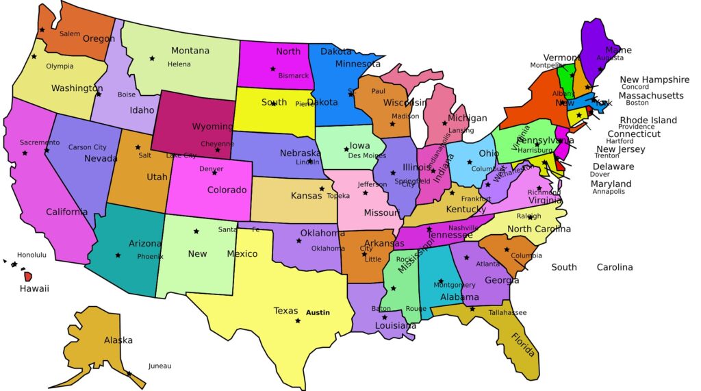
Capitals by States
Click on any State below to visit it’s official website
- Alabama – Montgomery
- Alaska – Juneau
- Arizona – Phoenix
- Arkansas – Little Rock
- California – Sacramento
- Colorado – Denver
- Connecticut – Hartford
- Delaware – Dover
- Florida – Tallahassee
- Georgia – Atlanta
- Hawaii – Honolulu
- Idaho – Boise
- Illinois – Springfield
- Indiana – Indianapolis
- Iowa – Des Moines
- Kansas – Topeka
- Kentucky – Frankfort
- Louisiana – Baton Rouge
- Maine – Augusta
- Maryland – Annapolis
- Massachusetts – Boston
- Michigan – Lansing
- Minnesota – St. Paul
- Mississippi – Jackson
- Missouri – Jefferson City
- Montana – Helena
- Nebraska – Lincoln
- Nevada – Carson City
- New Hampshire – Concord
- New Jersey – Trenton
- New Mexico – Santa Fe
- New York – Albany
- North Carolina – Raleigh
- North Dakota – Bismarck
- Ohio – Columbus
- Oklahoma – Oklahoma City
- Oregon – Salem
- Pennsylvania – Harrisburg
- Rhode Island – Providence
- South Carolina – Columbia
- South Dakota – Pierre
- Tennessee – Nashville
- Texas – Austin
- Utah – Salt Lake City
- Vermont – Montpelier
- Virginia – Richmond
- Washington – Olympia
- West Virginia – Charleston
- Wisconsin – Madison
- Wyoming – Cheyenne
Capitals by Cities
Click on any Capital City below to visit it’s official website
- Albany, New York
- Annapolis, Maryland
- Atlanta, Georgia
- Augusta, Maine
- Austin, Texas
- Baton Rouge, Louisiana
- Bismarck, North Dakota
- Boise, Idaho
- Boston, Massachusetts
- Carson City, Nevada
- Charleston, West Virginia
- Cheyenne, Wyoming
- Columbia, South Carolina
- Columbus, Ohio
- Concord, New Hampshire
- Denver, Colorado
- Des Moines, Iowa
- Dover, Delaware
- Frankfort, Kentucky
- Harrisburg, Pennsylvania
- Hartford, Connecticut
- Helena, Montana
- Honolulu, Hawaii
- Indianapolis, Indiana
- Jackson, Mississippi
- Jefferson City, Missouri
- Juneau, Alaska
- Lansing, Michigan
- Lincoln, Nebraska
- Little Rock, Arkansas
- Madison, Wisconsin
- Montgomery, Alabama
- Montpelier, Vermont
- Nashville, Tennessee
- Oklahoma City, Oklahoma
- Olympia, Washington
- Phoenix, Arizona
- Pierre, South Dakota
- Providence, Rhode Island
- Raleigh, North Carolina
- Richmond, Virginia
- Sacramento, California
- Salem, Oregon
- Salt Lake City, Utah
- Santa Fe, New Mexico
- Springfield, Illinois
- St. Paul, Minnesota
- Tallahassee, Florida
- Topeka, Kansas
- Trenton, New Jersey
Visit our main site about the 50 States at ‘List of 50 States‘
Capitals
The United States has a unique and evolving history of capital cities. The development of these cities reflects the growth of the country and the need for centralized administration.
The Capital
The history of the U.S. capital began during the Revolutionary War. From 1774 to 1789, the Continental Congress met in various locations including Philadelphia, Baltimore, Lancaster (PA), and Princeton (NJ), as war and politics forced mobility.
Philadelphia, the largest city at the time, served as a principal meeting place. In 1790, under the Residence Act, Congress established a permanent capital along the Potomac River, resulting in the creation of Washington, D.C.
The region of Washington, D.C., officially became the capital in 1800, after ten years of construction and planning under President George Washington’s direction. The capital was strategically chosen as a compromise between Northern and Southern interests.
Initially, the population of the new capital was under 10,000. Today, Washington, D.C. has a population of over 670,000 (2023), with more than 6 million in the greater metro area. It is unique in that it is not part of any state and is governed by a municipal government under federal oversight.
Colonial Capitals and Early Statehood
Before the U.S. was formally established, colonial capitals were centers of trade and governance for the British colonies. For example, Williamsburg served as the capital of Virginia from 1699 to 1780, before the capital moved to Richmond for its inland location and security during the Revolutionary War. Richmond remains the capital today, with a population of about 230,000.
Other examples of early capital movements: Savannah, Georgia was the colonial capital until 1786, when it was replaced by Augusta, then Louisville, and finally settled in Atlanta by 1868. Atlanta now has a population exceeding 500,000 and serves as a major economic and transportation hub.
New Bern, North Carolina was the capital until Raleigh was established as the permanent capital in 1792. Raleigh was chosen for its central location and today has over 470,000 residents.
Strategic Relocation and Planning
Many state capitals were deliberately chosen for political, geographic, or economic reasons. Often, capitals were relocated from populous coastal cities to more central locations as states expanded inland.
Illinois initially had Kaskaskia as its capital (1818), then moved to Vandalia in 1820, before settling on Springfield in 1839. Abraham Lincoln’s influence helped Springfield become the capital, and the city remains central to the state’s identity today with a population of about 115,000.
California went through several capitals – San Jose, Vallejo, and Benicia – before Sacramento became the permanent capital in 1854. Sacramento, with its strategic location at the confluence of two rivers and proximity to the Sierra Nevada gold fields, grew rapidly and now houses over 500,000 residents.
Capitals Built for Purpose
Some capitals were established intentionally as administrative centers rather than organically growing from population centers:
Pierre, South Dakota, was chosen in 1889 when the state was admitted to the Union. Despite its small size—under 15,000 residents—it was selected for its central location.
Juneau, Alaska, became the capital in 1906 when the government moved from Sitka. Juneau is unique because it is inaccessible by road, reachable only by sea or air, and has a population of about 32,000.
Olympia, Washington, was designated the territorial capital in 1853 and became the state capital upon Washington’s admission in 1889. Olympia’s population today is approximately 56,000.
Capitals with Large Populations
While many U.S. capitals are modest in size, some are major metropolitan centers: Phoenix, Arizona, became the state capital in 1912 and is now the most populous U.S. capital city with over 1.6 million residents.
Austin, Texas, designated as capital in 1839, has experienced explosive growth, now boasting a population of nearly 1 million.
Denver, Colorado, established as capital in 1867, is a major city with a population exceeding 700,000.
These cities serve not only as political centers but also as cultural and economic hubs for their states.
Capitals and State Identity
State capitals often embody a state’s political and cultural identity. For example, Boston, Massachusetts, has remained the capital since colonial times and is steeped in American revolutionary history. It has a population of about 700,000 and is a global center for education and healthcare.
Columbus, Ohio, became the capital in 1816, purposefully located in the geographic center of the state. Today, it has grown to over 900,000 people and is one of the fastest-growing cities in the Midwest.
Conversely, not all state capitals are the most prominent cities in their states. For instance, Albany, New York (population ~100,000), is the capital rather than New York City.Harrisburg, Pennsylvania (~50,000), is the capital despite Philadelphia’s historical prominence.
This discrepancy often results from historical compromises, central positioning, or attempts to avoid concentrating too much power in already large cities.
On Reflection
The history of capital cities in the United States is marked by strategic decision-making, geographic compromise, and evolving demographics.
From Washington, D.C.’s unique founding as a federal district to small capitals like Montpelier, Vermont (population ~8,000), these cities reflect the diverse needs and histories of the states they serve.
While some capitals are thriving metropolises, others remain relatively small, preserving a historic or logistical role rather than an economic one.
Together, they form the backbone of American governance at both state and national levels.